


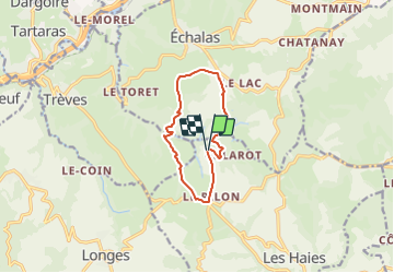
SityTrail - Echalas 10 a 261 g1 d

jtraverse
User

Length
10.2 km

Max alt
430 m

Uphill gradient
262 m
Km-Effort
13.6 km

Min alt
303 m

Downhill gradient
258 m
Boucle
Yes
Creation date :
2021-11-11 08:22:07.401
Updated on :
2021-11-11 08:26:48.078
3h05
Difficulty : Difficult

FREE GPS app for hiking
 SityTrail
IGN / Geographical institutes
SityTrail Plus
The world is yours!
About
Trail Walking of 10.2 km to be discovered at Auvergne-Rhône-Alpes, Rhône, Les Haies. This trail is proposed by jtraverse.
Description
GPS :
45°31'39.5"N 4°43'17.0"E ou 45.527636, 4.721374
69420 Les Haies
Positioning
Country:
France
Region :
Auvergne-Rhône-Alpes
Department/Province :
Rhône
Municipality :
Les Haies
Location:
Unknown
Start:(Dec)
Start:(UTM)
634419 ; 5043008 (31T) N.
Comments